Before I joined adelo’s health intelligence team, I mapped London’s obesity epidemic – discovering firsthand why understanding ‘where’ changes everything in health.
As an intern at adelo, I have been getting involved in a wide range of projects across data, marketing and strategy. One area that is central to adelo’s work – and something I have personally become increasingly interested in – is geomapping. At adelo, geomapping facilitates teams and leaders within the pharmaceutical and life sciences industry, to transform data into direction. By visualising and contextualising information, geomapping connects the what to the where, enhancing how strategies are devised and executed.
Before joining adelo, I experienced first-hand how powerful geospatial tools can be in uncovering health inequalities. Within my university dissertation, Untangling London’s Obesity Epidemic: A spatial exploration into the relationship between the food environment, socio economic status, and food choice, geomapping was indispensable for understanding the determinants of obesity in London. This has given me a deeper appreciation for the work adelo does every day.
What is geomapping and why does it matter in public health
Put simply, geomapping is the process of turning data into maps to reveal spatial patterns that aren’t visible in spreadsheets alone. In public health and pharmaceutical launches, this is crucial because understanding where people are affected is just as important as understanding what affects them.
Leveraging 8.5 billion data points, Adelo maps priority patient populations, access barriers, and key SDOH data with neighbourhood level precision. This level of geographic precision prevents wasted spend, avoids missed patients and mitigates the risk of ineffective market access. By uncovering these spatial patterns, adelo identifies underserved communities and highlights real world barriers to care, giving teams a precise understanding of the local context. These insights ensure that patient engagement, HCP outreach and adoption strategies are targeted and genuinely impactful.
How I utilised geomapping in my own research
Put simply, geomapping is the process of turning data into maps to reveal spatial patterns that aren’t visible in spreadsheets alone. In public health and pharmaceutical launches, this is crucial because understanding where people are affected is just as important as understanding what affects them.
Leveraging 8.5 billion data points, Adelo maps priority patient populations, access barriers, and key SDOH data with neighbourhood level precision. This level of geographic precision prevents wasted spend, avoids missed patients and mitigates the risk of ineffective market access. By uncovering these spatial patterns, adelo identifies underserved communities and highlights real world barriers to care, giving teams a precise understanding of the local context. These insights ensure that patient engagement, HCP outreach and adoption strategies are targeted and genuinely impactful.
Key insights I gained from geo-spatial analysis
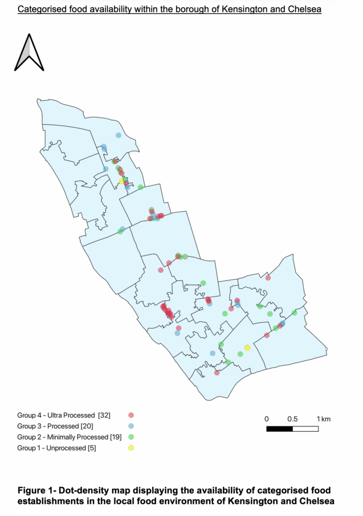
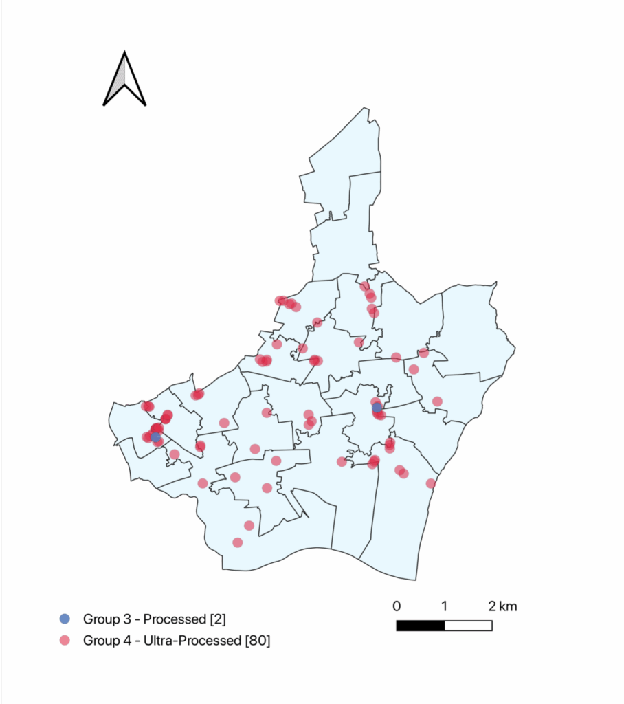
Implementing geomapping into my research for my dissertation fundamentally changed how I understand the management of public health. Using visual analysis, I discovered that the availability and affordability of healthier food matters far more than someone’s proximity to an unhealthy option. For example, there was a huge food desert in Barking and Dagenham whereby there was no access to healthy food outlets, whereas Kensington and Chelsea boasted a multitude of options. I also found that socio-economic status in both boroughs closely aligned with the disparity in the quality of the food environment and the prevalence of obesity. Ultimately it is the interplay between an individual’s socio-economic status and local environment that shapes their choices and access.
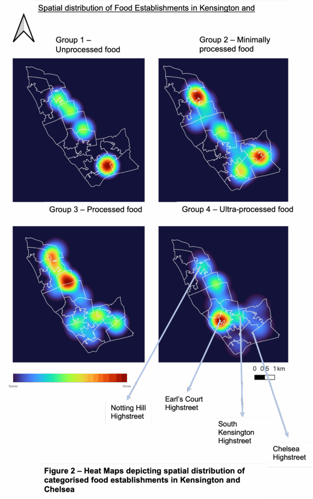
Geomapping shed light on the fact that obesity must be examined through a geographic lens and also revealed the need to look beyond single factors. My maps depicted a similar availability of ultra-processed food outlets throughout both boroughs with contrasting obesity rates, challenging previous literature that argued proximity to fast food is the main driver of obesity. Firstly, this emphasises that insights are highly context dependant. What applies in one setting cannot simply be transferred to another. As well as this, it displays the importance of overlaying different SDOH to gain a comprehensive view of obesity risk. Studying one factor, such as proximity, is not enough, it is how these determinants intersect within a specific geographic context that is crucial. Geomapping mitigates the risk of making false assumptions, and instead offers the geographic precision to build an accurate picture of the determinants in each place.
As a consequence, leaders and teams within the public health space are provided with targeted, community level insights which can guide more effective interventions, whether that be addressing disease management, planning public health strategies or supporting pharmaceutical launches. In the case of obesity, increasing access and reducing the cost of healthy food to target those in Barking and Dagenham who are underserved and high-risk. Geomapping helps planners, policy makers and organisations locate where action is needed, who is affected and build stronger evidence for investment and impact.

Personal reflection and conclusion
Reflecting on this experience, geomapping has demonstrated that health is spatial and without acknowledging the specific geographies of different places, vital patterns and insights remain hidden. My dissertation made it evident that to understand an issue like obesity, despite having global presence, must be studied at a local scale. Studying it through visual and layered SDOH data highlighted just how complex and place specific health outcomes really are. Geospatial intelligence is therefore indispensable for designing and executing healthcare strategies and interventions.
I am grateful for the opportunity to learn from and contribute to a company that not only recognises the importance of geomapping but actively implements it to drive meaningful impact and more equitable health solutions.
