
SDOH intelligence and geomapping
ZIP code predicts prescribing better than opinion
adelo Geomapping is built on 8.5 billion data points — social determinants of health (SDOH) intelligence, community health signals, activity data, and prescribing patterns — mapped at the ZIP code and postcode level. See where health barriers exist, where patient need is highest, and where your current deployment plan is missing the mark.

























Retail solved this problem twenty years ago
Tesco mapped the neighborhood. Kroger mapped the neighborhood.
Healthcare hasn't. Until now.
Every major retailer knows what to stock, where — because they connected purchase behaviour to local context. Tesco’s Clubcard at postcode level became the most valuable commercial asset in UK retail. Kroger’s data science team did the same in the US.
Healthcare has equivalent data and higher stakes. A patient in a food desert with limited pharmacy access responds to a GLP-1 prescription differently from a patient in a well-resourced suburb — even if their clinical profile is identical.
Adelo does for health what retail has done for decades — maps the community intelligence that determines outcomes.
60–80%
8.5B
1M+
ZIP
The gap that costs launches
Retail
Adjusts every shelf for every ZIP code. Different products, different layouts, different stock — because the community determines what sells.
KOL Profiling
Launches the same drug, the same way, everywhere — whether it’s a wealthy suburb or an area with 3× the diabetes rate and half the pharmacy access.
Adelo gives pharma the same neighbourhood intelligence that retail has had for decades.
SDOH intelligence layer
What adelo maps
8.5 billion data points. The world’s richest view of how populations live and engage with health.
Deprivation & SES mapping
Income, poverty index, employment stability — mapped to NUTS3 / ZIP code level across US & EU. The structural forces that determine whether a therapy reaches its population.
Food access & nutrition risk
Food desert mapping, critical for conditions where nutritional status correlates with outcomes. Over 1 million people in the UK alone live in food deserts with limited pharmacy access.
Healthcare access barriers
Transport infrastructure, specialist density, insurance coverage — identifying care deserts where diagnosed patients can’t reach treatment. Linkage-to-care intervention mapping by geography.
Demographic & ethnicity layers
BIPOC/H population concentration cross-referenced with disease incidence data. Identifying communities where burden is high but standard channel planning misses them entirely.
Specialist & HCP density
Specialist distribution mapped against population need. Where are there too few gastroenterologists for the IBD burden? Where are cardiologists thin on the ground for a cardiovascular launch?
Hidden population finder
Combining all layers: geographically surfaces communities with high disease burden but low HCP access, low treatment initiation, or invisible migrant and displaced populations that standard reporting never captures.
“SDOH intelligence is not just a launch tool. It is a Phase 3 trial design tool, helping sites be placed where the right patients actually live, not where they have historically been recruited from.”
Not a standalone data tool
An intelligence loop
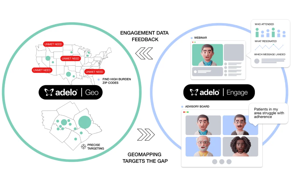
Geomapping feeds adeloEngage, and adeloEngage feeds Geomapping. Run a webinar — the engagement data tells you who showed up, what resonated, and which messages landed. Geomapping then shows you which high-burden ZIP codes had low attendance. Your next session targets the gap.
Before running an advisory board, Geomapping tells you which regions have the highest unmet need. adeloCapture runs the session with panellists from those geographies. When a KOL says “patients in my area struggle with adherence” — the platform already knows why.
Every session makes the map more precise. Every map makes the next session better placed.
In practice
Geomapping feeds adeloEngage, and adeloEngage feeds Geomapping. Run a webinar — the engagement data tells you who showed up, what resonated, and which messages landed. Geomapping then shows you which high-burden ZIP codes had low attendance. Your next session targets the gap.
Before running an advisory board, Geomapping tells you which regions have the highest unmet need. adeloCapture runs the session with panellists from those geographies. When a KOL says “patients in my area struggle with adherence” — the platform already knows why.
Every session makes the map more precise. Every map makes the next session better placed.
Built for every team in health

Pharma & Biotech
Map your launch before you deploy it. Identify hidden patient populations. Adjust territory strategy when adherence drops in real time.
Learn more

Consumer Health
Find the micro-markets with the strongest purchase intent before you commit national budget. Map lifestyle signals to campaign performance.
Learn more

Health Tech
Launch where validated demand exists. Know where your audience lives and what’s shaping their behaviour before you build for them.
Learn more
FAQS
Geomapping Common Questions
What is SDOH geomapping and how does it apply to pharma?
Social determinants of health (SDOH) geomapping maps the social, environmental and economic factors that determine health outcomes at ZIP code and postcode level. For pharma teams, this means understanding not just where patients are, but where they can and can’t access care, and where your current HCP engagement strategy is missing the mark. adelo Geomapping is built on 8.5 billion SDOH, lifestyle, prescribing and community health data points, giving medical affairs and commercial teams the richest available view of how populations live and engage with health.
How can geomapping improve drug launch performance?
Most drug launches treat geography as a delivery problem such as where to send MSLs and which territories to prioritise. adelo Geomapping reframes it as an intelligence problem. A doctor’s ZIP code often predicts their prescribing behaviour better than their stated opinion. By mapping disease burden, HCP density, pharmacy access and deprivation at postcode level, pharma teams can identify where patient need is highest, where current deployment plans are missing underserved communities, and which geographies need a completely different clinical conversation. Research consistently shows 60-80% of health outcomes are determined by social and environmental factors, not clinical care alone. Geomapping puts that intelligence to work before, during and after every HCP session.
What is the difference between geomapping and standard demographic data?
Standard demographic data tells you who lives where. adelo Geomapping tells you what that means for health outcomes and commercial strategy. It combines deprivation indices, disease incidence, food desert mapping, specialist density, BIPOC population concentration, healthcare access barriers and prescribing patterns into a single queryable layer down to postcode level. The result is neighbourhood-level intelligence that standard reporting never captures.
How does adelo Geomapping connect to HCP engagement sessions?
adelo Geomapping is an intelligence loop with adeloEngage and adeloCapture. Before a webinar, geomapping identifies which regions have the highest unmet patient need so you can target attendance accordingly. After a session, geomapping shows you which high-burden ZIP codes had low attendance and why. Before an advisory board, geomapping tells you which geographic communities should be represented in the room. Every session makes the map more precise. Every map makes the next session better placed.
Can geomapping help identify underserved patient populations?
Yes, this is one of the most powerful applications of adelo Geomapping. The Hidden Population Finder combines all SDOH layers to surface communities with high disease burden, low HCP access, low treatment initiation, or populations that standard channel planning misses entirely. Over one million people in the UK alone live in food deserts with limited pharmacy access. adelo Geomapping identifies precisely where those communities are and what that means for patient access, prescribing barriers and MSL deployment strategy.
How does adelo Geomapping support health equity in pharma?
See your market as it actually is
Free for 90 days. No credit card. Full platform.
